")
Receive our Newsletter
to stay informed: about updates, new products and solutions or exhibitions and conferences.
Subscribe to our Newsletter


Autonomous vehicles and vehicles with driver assistance systems operate in environments where there are often obstacles to GNSS signals. This leads to limitations in GNSS navigation performance. Navigation satellites are in constant motion. This means that the availability of satellites in direct line of sight is constantly changing. The accuracy of positioning based on GNSS also fluctuates with the number of reliably available satellites in a system.
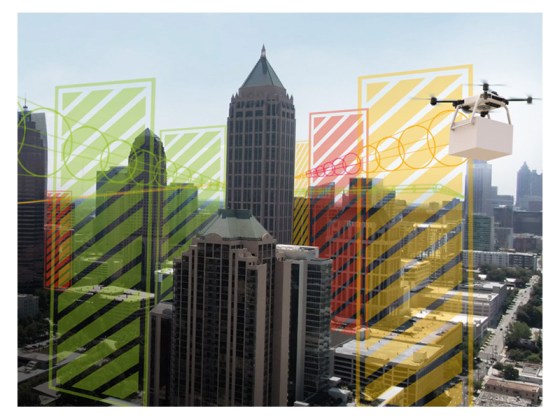
Spirents GNSS Foresight is a cloud-based prediction service that uses 3D maps of cities with their buildings and other reception obstacles and multi-GNSS information to find out where and when the signals of which GNSS satellites will be reliably receivable.
With this knowledge, the vehicle's assistance system can decide which of the navigation satellite systems is providing reliable signals at that moment and can block out multipath and stray signals from satellites that are not in the direct line of sight. It can prioritize the use of the GNSS component in areas where the signals are consistent and switch to other sensor information when they are not. This increases the performance of the entire system.
Foresight Live provides second- and square-meter-accurate forecasts of GNSS availability up to three days in advance. Environments where GNSS navigation was considered unreliable become predictable and accessible.
In addition to the cloud-based Foresight Live Service, it is also possible to create a risk analysis for a route. Foresight Risk Analysis GNSS Snapshots show where and when vehicles can navigate without serious GNSS errors and when remedial action is required. The Foresight Risk Analysis is provided in the form of data, heat maps and an analysis report.
to stay informed: about updates, new products and solutions or exhibitions and conferences.
Lange-Electronic GmbH
Rudolf-Diesel-Str. 29a
82216 Gernlinden
+49 8142 284582 0